Bay of Bengal – A Hotspot for Climate Insecurity
Below is a cross-post of Andrew Holland’s article originally posted on Sustainable Security, a blog run by the Oxford Research Group.
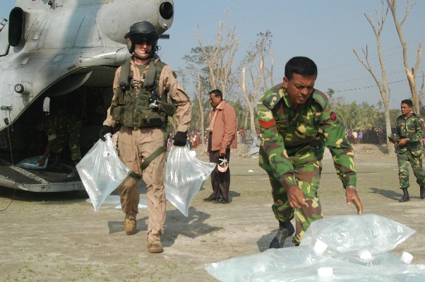
U.S. Marines delivering fresh water in Bangladesh
There is no region of the world that faces more threats from climate change than South Asia. Of particular concern is the littoral surrounding the Bay of Bengal, including the Eastern Indian states of West Bengal and Odisha, Bangladesh, and coastal Burma. This region is uniquely vulnerable to a changing climate because of a combination of rising sea levels, changing weather patterns, and uncertain transboundary river flows. Away from the seashore, China holds the high ground in the Tibetan Plateau and the Himalayas, and complicates the geopolitical picture further by acting as the source of the region’s fresh water.
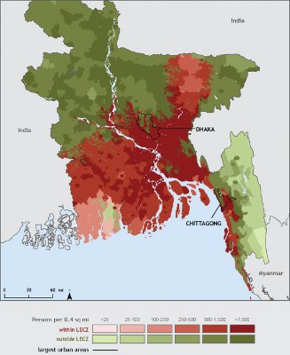
On the Bay of Bengal’s coast these problems of a changing climate combine with already existing social problems like religious strife, poverty, political uncertainty, high population density, and rapid urbanization to create a very dangerous cocktail of already security threats. Climate change has been called a “threat multiplier” or “an accelerant of instability” by military and intelligence communities because of how it will impact these already existing threats. With a population of more than 300 million people (91 million in West Bengal, 42 million in Odisha, 142 million in Bangladesh, 52 million in Burma), tense militarized borders, overlapping ethnic and religious communities, and uncertainty about the future, there is no region in the world that faces a more dangerous combination of threats from climate change than here.
Rising Sea Levels
One of the key tenets of national security is the ability of a country to ensure the integrity of its sovereign territory. Yet, as glaciers far from South Asia melt, the sea rises and encroaches upon its farms, villages, and cities. As Hemingway wrote about going bankrupt, sea level rise happens “gradually, then suddenly.” Slowly, a rising ocean brings increasing intrusion of brackish water into groundwater, harming coastal agriculture. Moreover, gradual ocean encroachment harms the coast’s natural protections, whether dunes, reefs, barrier islands, or mangrove forests. Then, suddenly, when a major cyclone blows in a storm surge will overcome previously unsurmountable barriers.
The shorelines of the Bay of Bengal stand to lose swaths of territory from sea level rise. Bangladesh, as a country predominantly composed of river delta, is most at risk. It stands to lose 11% of its territory – home to 15 million people – from a sea level rise of only 1 meter, a level that is not a particularly extreme prediction over the next 4 decades. Few invading armies could do worse damage.
Oddly enough, the world’s oceans do not rise at the same rate. With rising global sea levels, in some areas the sea level could actually fall while it rises in others. A recent study from the National Center for Atmospheric Research (NCAR) found that sea level rise will be particularly high along the Bay of Bengal, due to changes in currents caused by rapid surface warming of the Indian Ocean.
In the region, the cities of Dhaka, Kolkata, and Yangon all lie in major river deltas and are vulnerable to storm surges. In its 2007 report, the Intergovernmental Panel on Climate Change (IPCC) specifically listed cities in Asian mega deltas as “hotspots for vulnerability” because of sea level rise and changing patterns of river flow. Already straining at their infrastructure limits, these densely packed cities are becoming more vulnerable in a warming world.
Changing Transboundary Water Flow
Water does not stay within lines on a map. Instead, gravity draws it inexorably from the mountains to the sea. China, through its control of Tibet, controls the headwaters of almost all of the major rivers of Asia – only the Ganges lies outside of China’s control, originating in India. Of the major rivers that empty into the Bay of Bengal, all cross borders. Water is only plentiful during the monsoon season, so these rivers provide much-needed sustenance to agriculture, people, and ecosystems throughout their trip to the sea during the dry season – when they are fed by glacier and snow melt. Competition and tension over that flow is evident around the world when water crosses borders.
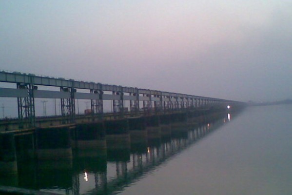
Courtesy “Walking Through India”
This is true of Bangladesh and India, for which the flow of the Ganges are a source of tension. The Farakka Barrage on the Ganges River, just 10 miles upriver from the Bangladesh border, allows India a measure of control over the river. The dam allows India to divert the flow of the Ganges down a canal to the Hooghly River and into the port of Kolkata. Since the dam was built in 1975, there have been allegations from Bangladesh that India diverts water in the dry season and releases too much in the monsoon season. In 1996, the two countries agreed to a 30 year treaty to share the Ganges’ flow, but tensions still remain.
The Brahmaputra River, meanwhile, provides a source of tension between the two regional powers, India and China. China recently announced that they are building a series of hydroelectric dams along the Brahmaputra’s upper reaches in Tibet, but they have forsworn any attempt to divert or hold back the great river’s flow. However, these assurances have not quieted all voices in India, who point to plans in China’s South-North Water Diversion Project to divert water from the Brahmaputra in order to ensure water for industry and the cities of China’s parched north. China’s leaders have deniedthese extravagant plans, but their engineers have lobbied for such a project. It would complete a dream of Chairman Mao’s, who said: “Southern water is plentiful, northern water scarce. If at all possible, borrowing some water would be good.”
Climate change exacerbates these concerns about transboundary water management in the region. Climate change is threatening both the glaciers that sit at the top of these mighty rivers, feeding them during the dry season, and the very viability and predictability of the Indian Monsoon rains. Temperatures in the Tibetan Plateau and the Himalayas haverisen 1.5 degrees Celsius since 1982, a rate more than three times as fast as the global average. Meanwhile, changes in weather patterns due to climate change could cause repeated failures in the monsoon. While there is little likelihood of an immediate and total melting of the glaciers, uncertainty about their future flows is enough to stoke tension in the region.
The Potential for Conflict
Climate change is altering the environment of the region; the glaciers are retreating, the rivers’ flows are becoming more unpredictable, and the seas are rising. However, whether those changes manifest themselves into either civil or interstate conflict will depend upon how both the populations and the governments in the region react to those changes. How long governments have to adapt depends upon unpredictable weather and climate patterns – but as the Stern Review bore out, earlier action is almost always cheaper and more effective than waiting. How governments adapt is important as whether; some adaptations, like capturing water that would otherwise flow across borders in new reservoirs could actually make the threat of conflict worse. If countries do not work cooperatively, they could stoke conflict.
Throughout history, one of the most effective ways to deal with climate change has been migration – from a climate that is no longer hospitable to one where living is easier. However, modern borders do not reflect the historical ties between the regions. Migration is a natural response. However, in areas with already high population density and an overlapping patchwork of ethnic and religious communities, new immigrant communities often come into direct conflict with established communities. Last year saw ethnic strife in the Indian state of Assam between indigenous Bodos and immigrant Muslims, many of whom hailed from over the nearby border in Bangladesh. Over 75 people died, and over 400,000 people were temporarily displaced. In this region, it is impossible to say whether a group of migrants are “climate refugees” or simply moving to a place with better economic opportunity, but this is what we should expect in the future.
It is difficult to find examples of any interstate wars fought directly over water; to the contrary, water has been a catalyzer of cooperation. However, as countries realize that they can control and shape water flow through mega dams and water diversion projects, there is a danger that the claims of downstream countries could be ignored. Along the Mekong River, for example, China has proceeded to dam and control the river’s flow through its territory – leading downstream neighbors to complain that China is causing droughts. Yet because of the power imbalance between China and smaller countries like Laos and Cambodia, the Chinese have little to fear. Similar thinking by Chinese leadership over dam building along the Brahmaputra, their shared river with India, could lead both countries to stumble into a conflict that neither of them want.
In the age of climate change, conflict is more likely as threats are multiplied. Nowhere is this truer than around the Bay of Bengal. However, war is never pre-ordained. Instead, the threat of conflict is determined by how countries react. Good international governance can encourage countries to not simply pull up the drawbridge and think only of themselves, but will encourage them to see what their actions will mean for regional neighbors. Climate change is increasing the threat of wars and unrest around the Bay of Bengal; but foresight about its impacts can help the region’s leaders work together to solve a problem that knows no boundaries.


[…] Bay of Bengal- A Hotspot for Climate Insecurity […]